This release was issued under a previous government.
As part of the recovery commitment, $110 million has been earmarked over the next three years to do expanded mitigation work on transportation infrastructure damaged by the June flooding and to protect other roads and bridges identified as at high-risk from future floods.
“Our transportation network was hard-hit during the floods, isolating communities and limiting movement of supplies and emergency services. By enhancing our flood defences and strengthening our existing infrastructure, we will protect families and communities and build our province for the future.”
Following the June flooding, more than 300 bridges and culverts and more than a thousand kilometres of highway were inspected. The closure of roads and bridges due to damage greatly impacted industry, tourism and the quality of life of Albertans. To prevent similar disruption in the future, government has also been working with partners, such as the Town of Canmore and the Hamlet of Exshaw, to identify the best ways to strengthen critical transportation infrastructure.
“Roads and bridges are vital links between communities and essential for emergency response. We saw how the devastation of the June floods affected Albertans, so we are taking this opportunity to protect communities and taxpayers from future flood damage by fortifying key infrastructure today.”
Funding breakdown
How the $110 million will be invested:
- $40 million for required mitigation work at sites damaged by the June flood (e.g. Highway 758 at Bragg Creek, Highway 1 at Cougar Creek and Dead Man’s Flats, Jura Creek in Exshaw);
- $70 million over the next three years to protect high-priority sites identified throughout the province as susceptible to flood damage. A priority list of the most vulnerable locations and those with the highest economic or societal impact will be developed as further assessments are completed.
Mitigation activities
Mitigation activities will include installing and enhancing protection works at bridges and highways adjacent to streams. This could include placing additional heavy rock, extending guidebanks, and other river training works. Projects may involve installing hazard management structures such as: rockfall nets and barriers, debris flow berms, catchment and storage ponds, or retention structures. Structures that currently provide insufficient openings for stream and debris flow will be upsized.
Working together
In a collaborative and proactive effort to alleviate future flood risks, the Town of Canmore commissioned the ‘Mountain Creek Flood Mitigation Study’ in July, with representation from industry, academia and the Government of Alberta. This study assessed the creeks and rivers that pass through Canmore and the mitigation measures that could be implemented to protect against flooding. Approximately $750,000 of Government’s 2013-14 transportation mitigation funding will go towards armouring Cougar Creek at Highway 1 and doing flood repairs along the Three Sister’s Parkway, priorities identified in the study.
“We’re really pleased that we’ve been able to join forces with the Province and other partners to look at the big picture. We examined what we needed to do to protect our respective infrastructure and how we could work together to ensure our mitigation efforts complement each other.”
Determining priorities
Mitigation efforts have been categorized by geographic region and highway classification. A “High Runoff Zone (HRZ)” has been identified as the portion of the province that has steep terrain, predominantly the area that drains the eastern slopes of the Rocky Mountains. This area is prone to more frequent large storm events, rapid runoff with little warning, and high-velocity flows that can result in significant bank erosion and stream channel relocation. Bridge structures located outside the HRZ, but that cross the major streams carrying water from this zone, have also been included.
Provincial highways have been grouped according to social and economic importance. The first priority is the national highway system with high traffic volumes, long trip distances, and significant inter-provincial traffic. The second is the arterial routes, with fairly high traffic volumes and relatively long trips within the province. Mitigation funding will be invested in the highest priority national and arterial assets within the HRZ to protect them from future flooding.
Under the Building Alberta Plan, our government is investing in families and communities, living within our means, and opening new markets for Alberta's resources to ensure we're able to fund the services Albertans told us matter most to them. We will continue to deliver the responsible change Albertans voted for.
Related information
Multimedia
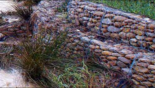
Photo Gallery: Flood mitigation activities
Interactive Map: Flood damage and repair
Map: “High Runoff Zone” and highway classifications (pdf)